The Genetec Cloudrunner’s Revolutionary Mapping: Transforming ANPR Investigations Through Geographic Intelligence
Read Nextro’s insight on how Genetec’s precision-based mapping and collaborative camera networks are reshaping vehicle-centric investigations
Genetec has fundamentally transformed how security professionals conduct vehicle-centric investigations with the introduction of advanced mapping capabilities and collaborative camera discovery for the Genetec Cloudrunner. These enhancements represent more than incremental improvements—they constitute a paradigm shift in ANPR investigation methodology, enabling unprecedented precision and collaborative reach across partner networks.
Precision Geographic Investigations Replace Manual Camera Selection
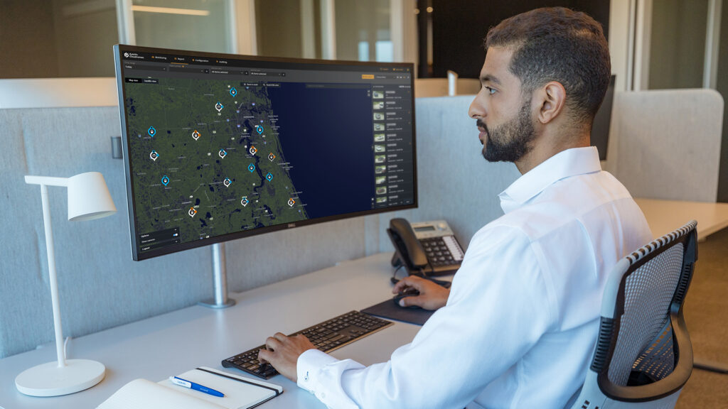
Traditional ANPR investigations required security operators to manually select cameras based on naming conventions, creating significant potential for oversight and inefficiency. The Genetec Cloudrunner’s new precision-based mapping eliminates this limitation through intelligent geographic search capabilities. The polygon tool within the Vehicle-Centric Investigation System (VCIS) allows investigators to define exact search areas on interactive maps, automatically including all relevant cameras within the selected region.
This geographic approach proves particularly valuable for complex facilities such as airports and ports, where camera networks span extensive areas with varied naming conventions. Rather than attempting to identify relevant cameras through potentially confusing asset names, investigators can simply draw their area of interest and immediately access all available vehicle reads within that geographic boundary. The system provides instant visual feedback, displaying read counts per camera and comprehensive tile views of all detected vehicles.
Collaborative Camera Networks Expand Investigative Reach
The Genetec Cloudrunner’s most significant advancement lies in its collaborative camera discovery and partnership capabilities. The new ‘Cameras’ tab reveals three distinct categories of available cameras: organisational cameras, existing partner cameras, and potential partner cameras marked as ‘discoverable’ by their tenant owners. This transparency enables investigators to identify gaps in coverage and opportunities for enhanced collaboration.
The streamlined partnership request process transforms what previously required complex negotiations into simple administrative workflows. When investigators identify relevant partner cameras during active investigations, they can flag potential partnerships directly to system administrators, who can then submit access requests efficiently. This capability proves invaluable for incidents spanning multiple jurisdictions or facilities, enabling seamless investigative continuity across organisational boundaries.
Real-World Applications in Critical Infrastructure
For New Zealand’s interconnected infrastructure networks, the Cloudrunner’s mapping capabilities deliver immediate operational benefits. Consider a security incident originating at an Airport and extending through surrounding commercial areas—investigators can now track vehicle movements seamlessly across partner camera networks without manual coordination delays. The geographic search tools ensure comprehensive coverage whilst collaborative features enable rapid access to additional camera resources.
Similarly, port security operations benefit from the ability to define precise perimeter searches and identify vehicle patterns across extended facility boundaries. The mapping interface provides intuitive visualisation of vehicle behaviours and movement patterns, enabling security teams to identify reconnaissance activities, track suspicious vehicles, and analyse operational trends with unprecedented clarity.
Enhanced Investigative Workflows and Pattern Analysis
The Cloudrunner’s mapping integration transforms investigative workflows by combining geographic precision with comprehensive vehicle data analysis. Investigators can apply multiple filters—including number plate characteristics, vehicle colour, and type—within specific geographic boundaries, immediately visualising results through both map displays and detailed tile views. This integrated approach enables rapid identification of target vehicles and comprehensive analysis of their movement patterns over time.
The ability to track driving behaviours and patterns across geographic regions provides valuable intelligence for both immediate investigations and long-term security planning. Security professionals can identify recurring patterns, potential vulnerabilities, and suspicious activities that might otherwise remain undetected through traditional investigation methods.
Strategic Implementation for Maximum Effectiveness
Organisations implementing the Genetec Cloudrunner’s advanced mapping capabilities should prioritise camera discoverability settings and partnership strategies. The collaborative features function optimally when camera networks are appropriately configured for discovery and partnership requests, enabling maximum investigative reach across regional security communities.
The polygon search tools require minimal training but deliver substantial efficiency improvements, particularly for organisations managing extensive camera networks across large geographic areas. Security teams should consider integrating these mapping capabilities with existing investigation protocols to maximise operational benefits whilst maintaining comprehensive documentation standards.
The Evolution of Collaborative Security Intelligence
The Genetec Cloudrunner’s mapping advancements represent the future of collaborative security operations, where geographic intelligence and partnership networks combine to create comprehensive investigative capabilities. As these technologies mature, organisations that embrace collaborative ANPR networks will possess significant advantages in incident response, pattern recognition, and community-wide security coordination.
For security professionals managing critical infrastructure, commercial facilities, or transport networks, the Cloudrunner’s enhanced mapping capabilities offer immediate opportunities to improve investigative efficiency whilst building stronger collaborative relationships across the security community.
Discover how Genetec the Cloudrunner’s new advanced mapping capabilities can transform your security investigations. Contact Nextro’s specialists to explore implementation opportunities.